Lakeline Reach 1 Capacity Improvements
Project Details
Reach 1, located along the east side of the Island, begins at 4266 E Mercer Way and terminates at King County’s South Metro Pump Station, (PS-KCS), 9603 SE 72nd Street. This reach includes City pump stations PS 25, PS 24, PS 23, and PS 22, as well as approximately 13,350 feet of 8- to 14-inch cast iron lakeline. The lakeline itself runs adjacent to 170 properties and under 150 docks.
Background
Mercer Island’s sewer collection system includes approximately 105 miles of gravity mains, 2,400 manholes, 17 pump stations, and one flush station. A key component of the system is the lakeline—a series of low-pressure sewer mains located 5 to 100 feet offshore that convey wastewater along the island’s perimeter. The lakeline collects flows from both residential connections and pump stations, ultimately discharging to King County’s North Metro (PS-KCN) and South Metro (PS-KCS) pump stations for off-island treatment.
The lakeline is divided into five hydraulically distinct segments, or “reaches.” The condition of Reach 1 is currently unknown, primarily due to the lack of access points, which has prevented inspection, maintenance, and upgrades since its original installation in 1966. This absence of condition data underscores the need for a comprehensive assessment and long-term planning to address potential capacity and reliability issues.
Description
The purpose of this project is to provide comprehensive engineering design and support services for the Lakeline Reach 1 Capacity Improvements Project. This is a complex, multi-year effort focused on identifying and addressing system deficiencies within Reach 1 to ensure reliable flow capacity and prevent future Sanitary Sewer Overflows (SSOs). Anticipated activities include data collection, planning, field reconnaissance, surveying, condition assessment, modeling and analysis, permitting, and design and engineering support for preliminary, small-scale, and full-scale construction efforts. The work will be delivered in clearly defined phases to address priority needs and accommodate evolving conditions.
Project Timeline
Planning/Design: August 2025 – June 2027
Construction Timeframe: June 2027 – December 2028
Estimated Budget
$3,099,208
Contact:
Christopher Marks, Utilities Engineer, 206-677-1027; chris.marks@mercerisland.gov


 placed on the pipe or side sewer to trace and accurately map the lakeline.")

Status Updates
May 29, 2026

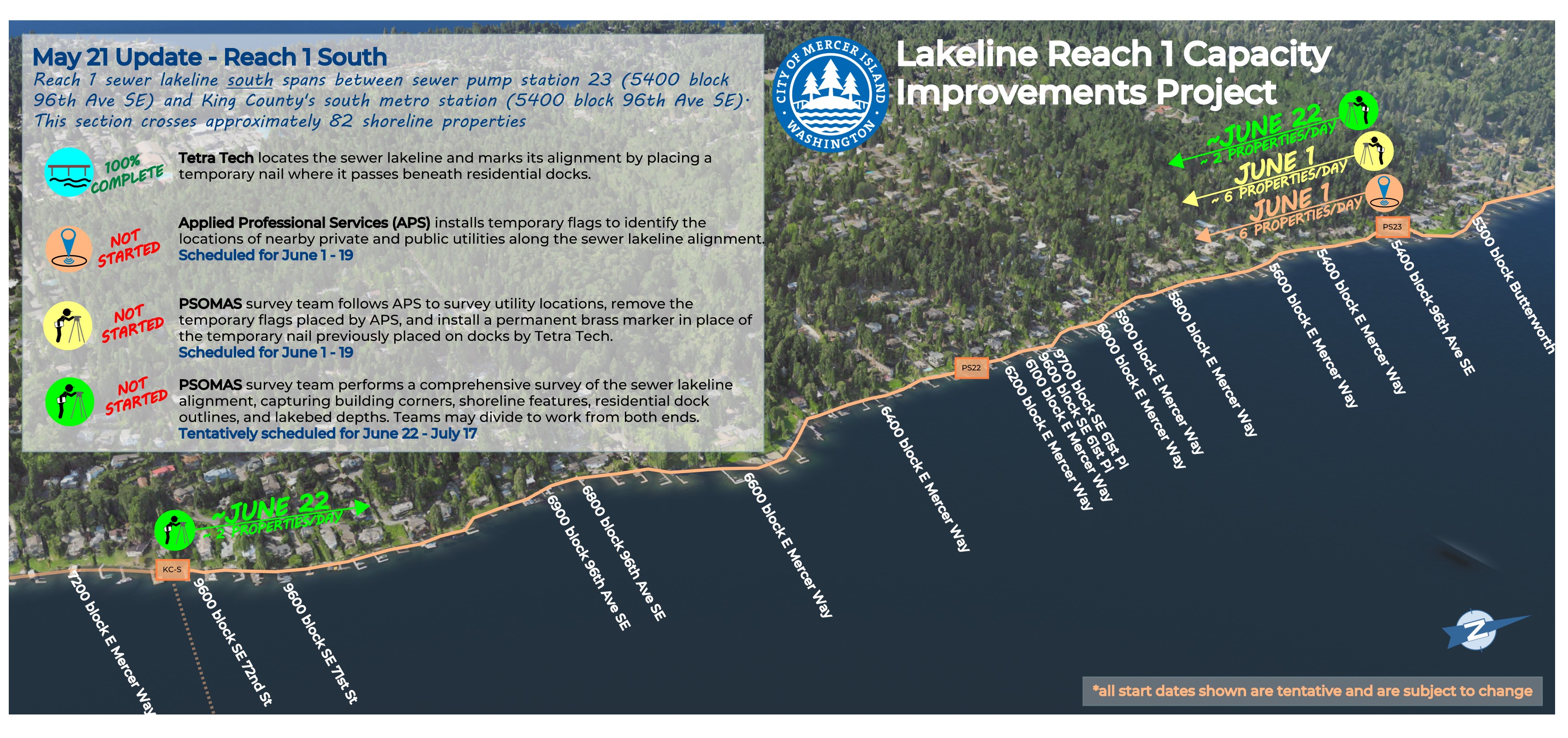
All locating and survey work in the north half of Reach 1 is now complete, and beginning June 1 crews will begin work on the southern half, covering 82 shoreline properties along E Mercer Way. This work will occur in two phases: Phase 1 includes utility locates and initial dock and lakebed surveys, progressing south at roughly 6–8 properties per day. Phase 2, beginning June 22, will include a comprehensive survey of docks, shoreline features, and lakeside building corners, with two teams working inward from each end at about 2 properties per day. Residents will see survey crews along the shoreline as this work continues.
April 23, 2026

Utility locating along the sewer lakeline alignment for the 88 shoreline properties between the 4200 and 5400 blocks of E Mercer Way is complete. Flags that were placed to mark those utilities have since been surveyed by the PSOMAS team and removed.
Now, two PSOMAS surveyors are conducting detailed mapping from opposite ends of the northern half of Reach 1. Due to dense tree canopy affecting GPS signal and line of sight, along with the high number of required survey points, each crew is progressing at approximately two properties per day. Completion of the northern half is anticipated by May 15.
Survey efforts for the southern half are currently paused pending completion of the north half, with mobilization expected as early as May 11.
April 9, 2026
The Tetra Tech lakeline locating team completed work this week near the 7200 block of E Mercer Way, marking sewer lakeline alignments across approximately 170 properties and docks. Utility locating (APS) and surveying (PSOMAS) teams have now begun work near the 4200 block of E Mercer Way and are moving south along shoreline properties at a pace of about 7–8 properties per day. APS is marking nearby utilities, while PSOMAS is surveying these locations along with shoreline features, lakeside structures, docks, and the sewer lakeline. Due to the detailed nature of the survey, a slower pace and repeat visits to properties are expected
April 2, 2026
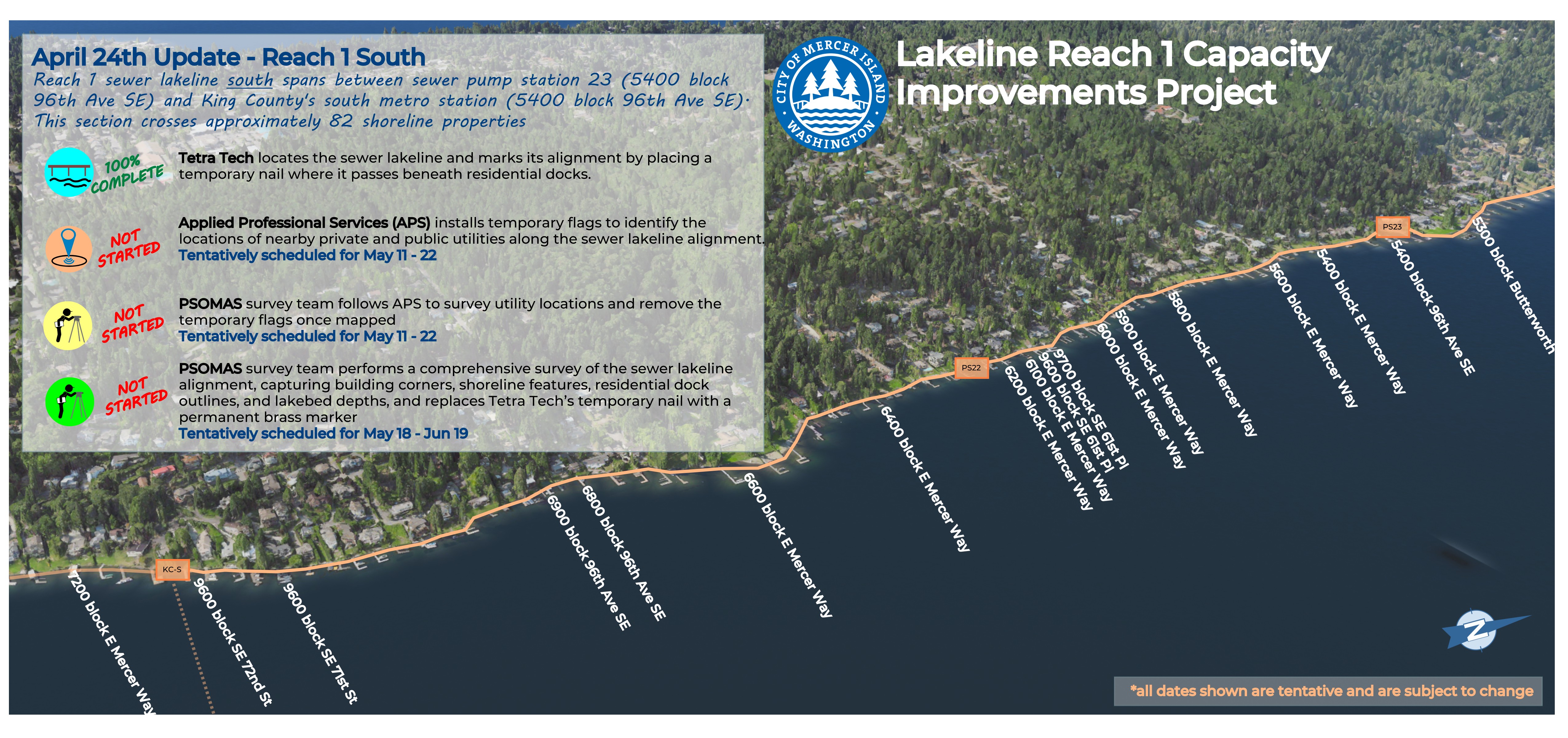
Next week, Tetra Tech will continue locating the sewer line and placing temporary markers where it crosses beneath docks south of sewer Pump Station 23. This work impacts 82 properties along the shoreline between the 5400 and 7200 blocks of E Mercer Way. Affected residents should have already received a mailed notice and will also receive a door knock on the day of the work.
Also next week, crews from Applied Professional Services (APS) and PSOMAS will be working along the shoreline between the 4200 and 5400 blocks of E Mercer Way, trailing earlier work by Tetra Tech. This work will affect approximately 88 properties. APS crews will place temporary flags to mark public and private utilities. PSOMAS will complete final survey work, including mapping the sewer line, shoreline features, docks, nearby structures, and utilities. Crews will also replace temporary sewer line markers with permanent markers at docks. PSOMAS crews will follow APS by one to several days. All affected residents will receive a door hanger at least 24 hours before work begins.
March 27, 2026
This past week, Tetra Tech finished locating the sewer lake line between the 4200 and 5400 blocks of E Mercer Way. Instead of what was originally planned, temporary markers were placed on resident docks to show exactly where the line crosses underneath. These will be replaced with permanent markers by survey crews in the next couple of weeks. Work will continue moving south next week, with crews accessing the lakeside portions of properties to locate the sewer lake line between the 5400 and 7200 blocks of E Mercer Way.
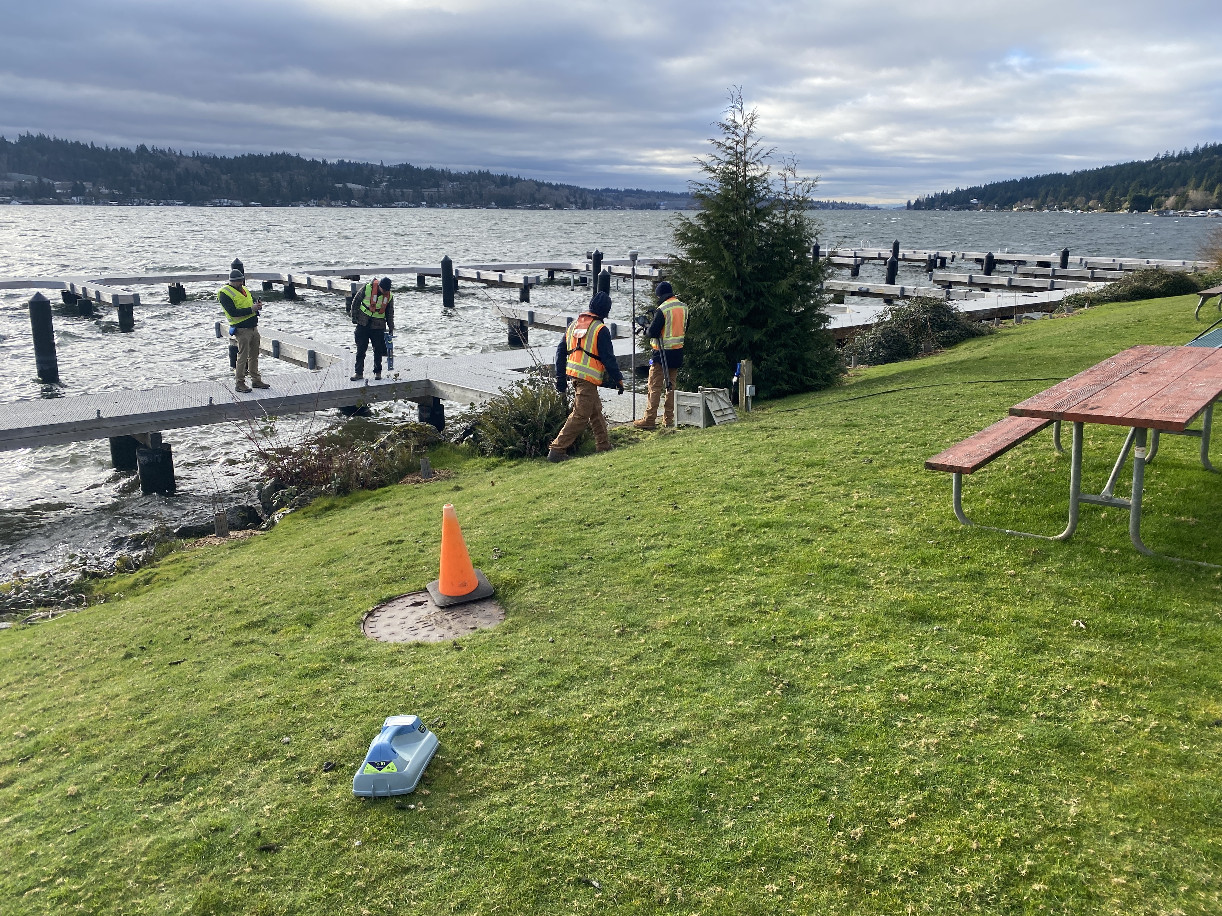
March 13, 2026
From March 23 through May 1, City of Mercer Island staff, along with Tetra Tech and Psomas, will conduct a sewer lakeline field investigation between the 4200 and 5400 blocks of East Mercer Way. The work will cross 88 of the 170 waterfront properties along the Reach 1 corridor, with activities at each property expected to take approximately one hour. Crews will locate and document the lakeline and related infrastructure and install a small permanent survey marker on docks where the pipe crosses beneath. Multiple visits may occur to allow different survey and inspection team members to complete their work. Properties to be visited will receive an informational mailer in advance and also a day-of notice prior to site access.
February 27, 2026
The preliminary sewer lakeline investigation was conducted this Thursday. City staff, along with Tetra Tech and Psomas, used non-acoustic signal tracing methods to successfully locate the lakeline across several properties. This initial effort helped identify the most effective locating techniques and gather key information to support the broader investigation planned for early this summer across all 170 properties within Reach 1.
February 20, 2026

Next week, City staff, along with Tetra Tech and Psomas, will conduct a preliminary field investigation of the sewer lakeline across approximately ten waterfront properties, located in the 4200 and 5400 blocks of East Mercer Way. The purpose of this first effort is to evaluate locating methods and assess the time and labor required to complete a comprehensive survey. This preliminary work will inform a future sewer lakeline survey across all 170 waterfront properties along the 2.5-mile Reach 1 corridor. The full survey will document the lakeline and associated features such as docks, bulkheads, sewer clean-outs, and adjacent improvements. Crews will access the lakeline through existing sewer utility easements.
February 3, 2026
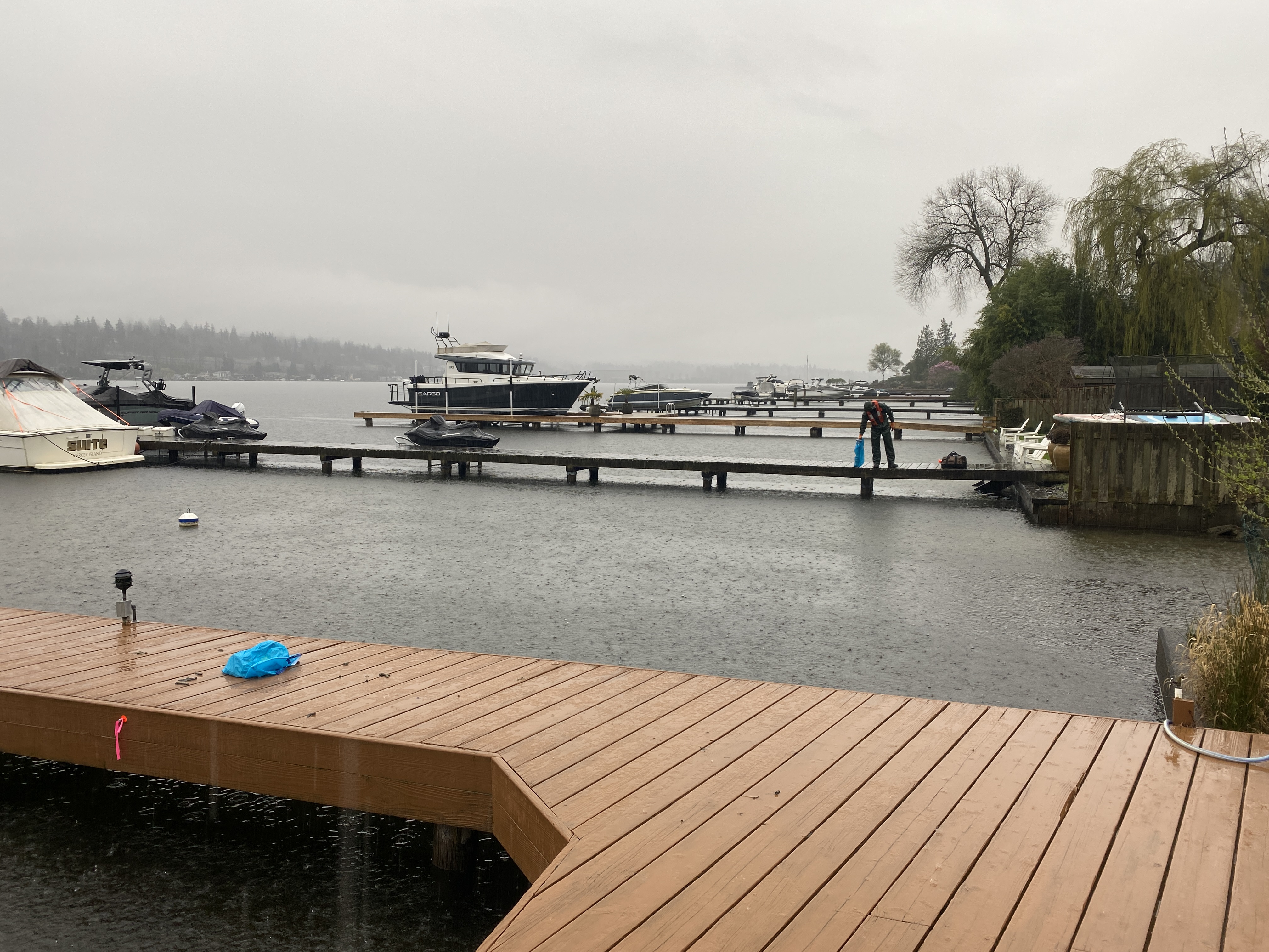
On Tuesday, February 3, a sewer lakeline inspection team made up of City staff and consultants from Tetra Tech, Psomas, Carollo, and Confluence investigated the 2.5-mile stretch of sewer lakeline Reach 1 by water. If you live along the east side of the Island between Mercerwood Shore Club and SE 72nd Street, you may have noticed the boats moving slowly along the shoreline. The purpose of the effort was to photograph, locate, and conduct a preliminary field investigation of the sewer lakeline—a 10- to 14-inch cast iron pipe that conveys approximately 150,000 gallons of sanitary sewer each day to the King County South Metro treatment facility.
January 30, 2026
City staff and the project consultant team will conduct a boat-based reconnaissance of the Reach 1 project area next week. The visit will provide an initial look at shoreline conditions, pump stations, dock markers, and any visible portions of the sewer lakeline along the 2.5-mile stretch of Reach 1 of the sewer lakeline. This is the first of several planned site visits to document existing conditions.
December 12, 2025
The project team held its official kickoff meeting this week. City staff, primary design consultants Tetra Tech, Carollo, and Psomas, as well as nearly a dozen specialized subconsultants came together to review the project schedule, confirm key deliverables, and establish initial action items to launch the effort. As the team begins reviewing background information and collecting essential project data, planning is underway for a boat-based reconnaissance tour in January. This field visit will provide an up-close assessment of the lakeline and adjacent shoreline areas within Reach 1.
June 13, 2025
On May 12, the City issued a Request for Qualifications (RFQ) seeking statements of qualifications (SOQs) from engineering firms for design and support services related to the Lakeline Reach 1 Capacity Improvements Project. This week, following a thorough evaluation of the submitted SOQs, the City identified Tetra Tech as the most qualified firm. Contract negotiations are currently underway.